Now, when we talk about the blank map of ancient India, we’re not looking at what we have today, but back to a time when things were a bit different. You see, ancient India wasn’t just the country India like we know it now. Nope! Back then, it covered a whole area that today includes Pakistan, Bangladesh, and parts of Afghanistan. People say the land was rich with rivers, mountains, and flat plains. And on a blank map, oh, there’s so much you could add if you knew what you were looking for.
Ancient India sat in a good spot. It was surrounded by big bodies of water, like the Bay of Bengal to the east, the Arabian Sea to the west, and the grand Indian Ocean down south. Up north, it wasn’t so easy to get in because of the tall Himalayas. These mountains kept people out. But, you know, there’s always a way if you look hard enough. For instance, the Khyber Pass in the northwest made it possible for people to come in, even though it was a tough journey.
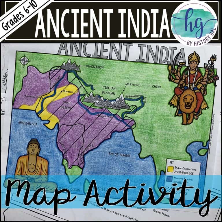
People lived in this region a long, long time ago—way back in prehistoric times, thousands of years before Christ. They started settling by rivers, planting crops, and raising animals around 7000 BCE. Now, those people, who lived near the Indus River in places like Harappa and Mohenjo-Daro, were from the Indus Valley Civilization. These people made pottery, built cities, and knew how to live off the land, didn’t they?
Now, what would you find on a blank map of ancient India? Well, there’d be the big rivers like the Indus River to the west, and the Ganges River to the east. The Indo-Gangetic Plain, stretching across the top, was a flat land good for farming. Then, moving south, there was the Deccan Plateau, right in the middle of the peninsula. To the west and east, you had the Western Ghats and Eastern Ghats, two long mountain ranges that lined the coast like walls, keeping the rains over the land and making it nice and green.
Now, these ancient people didn’t have the internet or maps like we do today. They traveled and learned about the land by foot, maybe with a little help from word of mouth. They didn’t call themselves “Indians” like today. Instead, they were part of different tribes and groups, each one knowing a bit of the land they lived on. And over time, these groups mixed and mingled, bringing in new cultures and ways of life.
Around 1500 BCE, there came a group called the Aryans. They brought with them the Vedic culture, which blended with the local traditions. These people spoke an old language called Sanskrit and laid down some early traditions, including the Vedas, the religious texts. Over the years, this mix became the roots of Hinduism, a big part of Indian culture even today.
But on a blank map, you wouldn’t see all these people, just the places where they lived. You’d have the mountains, rivers, and plains that made up ancient India. This map would show how big and diverse the land was, stretching from the snow-covered Himalayas down to the southern coasts along the Indian Ocean. Ancient India was no small area, I tell you!
If you were marking up a blank map of ancient India, you’d also note the Western and Eastern Ghats, which kept the central lands safe from too much wind and rain, while letting the monsoon sweep in to make everything grow. You’d mark the plains and the plateaus, showing the lay of the land where people farmed and lived.

And let’s not forget about those mountain passes. The Khyber Pass, for example, was important because it let people come in from the northwest. It was through passes like these that traders, explorers, and even invaders traveled. They brought new ideas and goods with them, making ancient India a hub of culture and trade. But these passes also meant that India had to defend itself from time to time.
So, a blank map of ancient India would be more than just lines and names. It would be a place rich with stories of old civilizations, early farmers, ancient cities, and wise thinkers. It’s more than what we see on a map today, even with all its blank spots. And if you ever look at one of these maps, you’ll know that each mark and line holds a part of history, going back thousands of years. Imagine that!
Tags:[ancient India, blank map of India, Indus River, Himalayas, Deccan Plateau, Khyber Pass, Western Ghats, Eastern Ghats, Indian subcontinent]